|
Directions to events and other activities
|
|
|
SGL #119 and Army Corp of Engineers
White Haven, PA
GPS Coordinates for training meetup area (pavilion):
41°07'46.3"N 75°44'16.4"W
GPS Coordinates for the testing meetup area:
41°07'48.7"N 75°43'51.2"W
|
From the intersection of the Northeast Extension, Interstate 80 and State Rd 940. See Google Maps.
If Walter Dam Rd is open. From the intersection of Rt 80 and Rt 940
Head East on PA-940 1.1 mi
Turn left on Walter Dam Rd 2.5 mi
Turn left over dam 1.2 mi
Turn Left after dam 1.0 mi
At T intersection cross State Rd 2041 and bare left for SGL #119 parking or right on dirt road through
red gate for Army Corp of Engineers parking.
If the Walter Dam Rd is closed take Rt 80 to White Haven Exit
Take I- 80 exit 273 for PA-940 toward PA-437/White
Turn right onto PA-940 E/Church St - 0.3 mi
Turn right onto Berwick St - 0.2 mi
Turn left at the 3rd cross street onto Towanda St - 0.5 mi
Continue onto Chesnut St/Middleburg Rd - 2.8 mi
Continue onto Cross Dr - 1.6 mi
Continue onto White Haven Rd - 1.1 mi
Army Corp of Engineers will be on your left
|
|
|
SGL #40
Coordinates for the parking area
41°03'28.9"N 75°44'58.1"W
|
From the intersection (Exit 95) of the PA Turnpike Northeast Extension
(Rt 476) and I-80 go West on I- 80 for approximately 2 miles to the
Hickory Run Exit (Exit 274). Proceed up the ramp to the stop sign
and turn South (left) toward Hickory Run State Park.
For those coming from the West on Route 80 get off at the Rt 80 Hickory Run Exit (Exit 274). Proceed
up the ramp to the stop sign
and turn South (right) toward Hickory Run State Park.
Approximately
200 hundred yards from I-80 on the left is the small State
Game Lands parking area. There
is a golf course on the opposite side of the road.
|
|
|
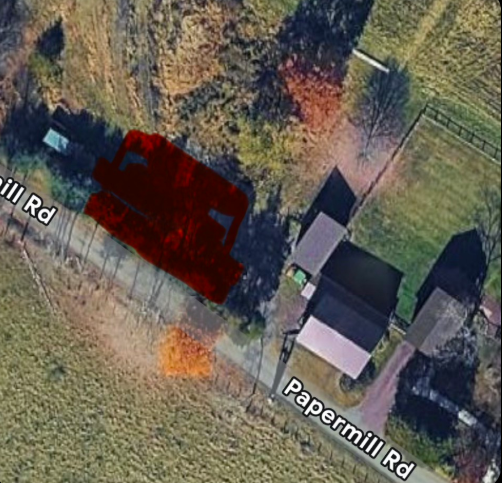
Holt Farm
110 Papermill Road
Barto, PA 19504
Coordinates: 40°22'54.0"N 75°32'23.7"W
|
Google Map (Parking Area)
Note that the address will take you to the house - but parking is between the bird pen and the garage
(highlighted in red) marked in the photo below and pinned in the map link above.
|
|
|
State Game Land 91
Mud Pond
Meet at the parking lot entrance to Mud Pond on Northeast side of Thornhurst Road. The parking lot is
fairly limited so some will need to park along the road until the gate is opened.
|
Google Maps and Directions
Coordinates 41°13'34.3"N 75°41'18.1"W
The entrance to Mud Pond is located approximately 20 minutes Northeast of the Army Corp of Engineers
parking lot.
1. Head northeast on White Haven Rd - 4.9 mi
2. Sharp right onto PA-115/Bear Creel Blvd - 1.9mi
3. Turn left onto Meadow Run Rd. - 3.6mi
4. Continue on Suscon Rd/Thornhurst Rd - 0.2mi
5. Turn left onto Thornhurst Rd - 1.1mi. Destination is on the right.
|
|
|
Rossi Farm located at 285 Pullen Station Rd, Quakertown, PA
Coordinates: N40.49502
W075.29301
|
Rossi Farm, Google Maps for
directions
Depending on field conditions parking will be along the lane shortly after the turn off Pullen
Station Rd. Please do not drive to the house which is occupied unless directed to.
If your GPS tries to bring you to the property from the north via Molasses Way you will find that
Molasses Way is an unimproved dirt road. You will need to drive to Pullen Station Rd and come in that
way.
|
|
|
Foglesville
State Game Lands 205
GPS Coordinates>
N40°39.986'
W075°39.315
Note: Presumably because of the lack of paved roads your GPS may go into recalculating
mode as you get within a mile or two. In that case revert to the old way of using the written
directions.
|
From Rt# 100 and I-78 -- Google Maps
1.) Take Rt# 100 north apprx. 10 mi. from # I-78, If you reach the
T intersection of Rt 100 and Rt 309 you went about a mile to far.
2.) make right turn onto Sell Rd. (apprx. 2 mi. south of Rt# 309)
Should see a KOA Campgrounds sign.
3.) go apprx. 1/4 mi. and make right turn onto Warden rd. (dirt).
4.) take warden road apprx.2 mi. to where it splits and make left
onto Kistler Rd. (black top)
5.) go only apprx. 1/4 and make right onto poplar rd. (dirt) and go
to top of hill (apprx. 1mi)
6.) make right at top of hill into game land parking lot.
|
| |
|
| |
| |